What it’s like to road trip from Alice Springs to Port Fairy

hero media
Robyn Rosenfeldt embarks on an odyssey from the middle to the edge, from Alice Springs to Port Fairy, and watches the Australian landscape change with each turn of the wheel.

I look around. There’s not a tree in sight. The summer sun is belting down hard on the red earth. From this vantage point I can see no water, no shelter and for that matter no life. And I’m going to spend the next nine days driving through this. What on earth am I thinking?
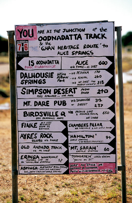
Crude but effective, this is the signpost that greets you at the beginning of the Oodnadatta Track. Image by Robyn Rosenfeldt

All of this is observed from the comfort of my airline seat as I fly from Melbourne to Alice Springs. In two days’ time I’ll drive out from Alice with three friends, on a journey that will take us clear across the country. South from Australia’s hot, dry centre, along the Old Ghan Railway Heritage Trail, the Oodnadatta Track, through The Northern Flinders Ranges, down into NSW to Lake Mungo National Park, on to Mildura and then across Victoria to our final destination – the sparkling coast at Port Fairy.
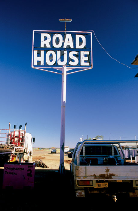
The Oodnatta Roadhouse. Image by Robyn Rosenfeldt

Trailing the Old Ghan

As we drive south through The Gap, the point at which the Todd River cuts through the MacDonnell Ranges and which marks the outskirts of Alice Springs, we’re all excited to be on the road. Our big red Toyota is packed with swags, food, guitar, eskies, beer and – most importantly – spare diesel and water.
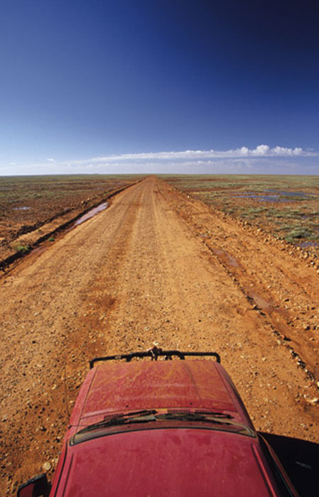
Driving through the flat expanse on the Old Ghan Heritage Trail. Image by Robyn Rosenfeldt

We turn off the Stuart Highway down the Old South Road and, as the wheels spin on the red earth, our adventure begins. The first part of our journey will follow the Old Ghan Railway Line that was abandoned when it was replaced with the current Ghan Line, which runs further west. Named after the afghan traders that rode their camels through these parts, the railway follows the old telegraph line, the construction of which was the impetus for Burke and Wills’ fateful journey.We head south along the dirt red track, past Mt Ooraminna, which we climb before stopping at Bundooma, an old railway siding, for lunch. We’ve barely gone 50km on our journey when we’re almost stopped altogether by swollen rivers crossing the road. Just south of Finke, we come across a creek that has burst its banks and is flowing quickly and deeply across our path. And here I thought this was supposed to be the desert.


To be completely safe, we decide to wade through the river before driving, to check the depth and strength of the current. With water thigh high and almost fast enough to knock us over, we’re a little nervous about driving into it. But we realise there’s no going back, so we give it a go; our big red truck forges a path like Moses through the Red Sea.


We cross four more swollen creek beds, none quite so deep or fast-flowing, and come out the other end just as the sun is setting, turning the surrounding countryside a fiery radiant red. After stopping to collect firewood and admire the scenery, we find our camp for the night, a glade of red mulga trees by a dry creek bed. Kicking back on our rolled up swags, cool beers in hand, we cook and eat dinner beneath the stars. After a few songs around the campfire we roll out our swags. As I lie watching the stars twinkle through the mulgas, with the breeze blowing across the desert plains, I feel high on life. This is the way to live, out in the elements, in touch with nature.


After a quick stop in the morning at the Mt Dare Hotel we drag our swags beneath the shady palms and have lunch, followed by a siesta. Taking our time, we follow the track on to the Oodnadatta through Fogarty’s clay pan, just in time to have a beer at the Oodnadatta pub and find a spot to camp on the clay pans on the outskirts of town. to fill up on fuel and water, we head out to Dalhousie Springs, where water temperatures reach 43 degrees. Just near the springs the old telegraph station buildings stand in varying states of disrepair, beside a mound spring oasis.

Need tips, more detail or itinerary ideas tailored to you? Ask AT.

AI Prompt

Stranded at Lake Eyre…

The salt on the surface of Lake Eyre forms a dry crust, under which lies soft brown sludge. We’re fully aware of this as we drive out on to it, watching the tyres to make sure the earth beneath us is still holding firm. But, like many adventurers, we creep out too far and . . . squelch. We’re stuck. The wheels are spinning and the car’s not moving.Now, just to paint a clear picture of our situation: we haven’t seen another car all day, we have no means of communication and we’re a long way from help. Things are looking dire, so we get the lightest member of our team to jump in the driver’s seat, the boys roll up their sleeves and start pushing, leaving me to do what seems most appropriate in this sort of situation: start taking photos. That is until I’m yelled at. I join in the pushing, eventually the tyres find traction, she rolls on the tracks we came in on and – aaah – sweet, solid ground. That was a little too close.
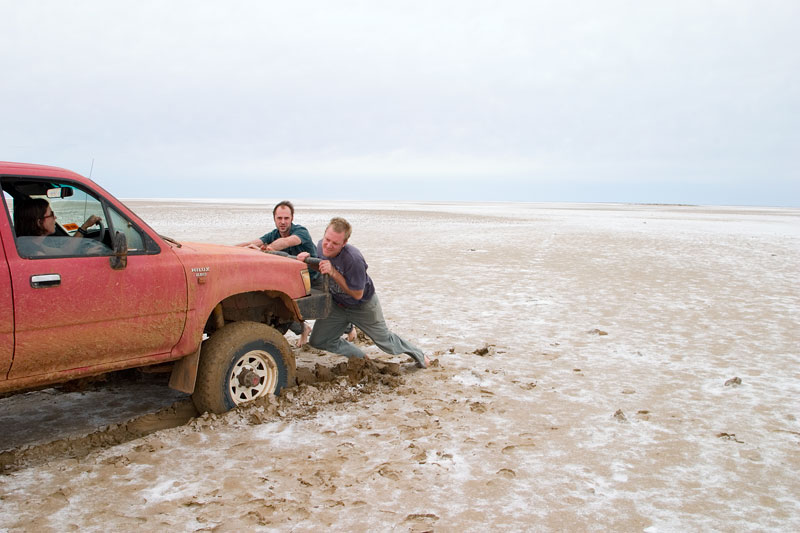
A close escape on Lake Eyre. Image by Robyn Rosenfeldt

Walking out on to Lake Eyre is like traversing a moonscape. The endless expanse of white stretches out all around you. With an overcast overhead, it’s difficult to see where the sky ends and salt begins. We walk out until all we can see is white in all directions. We’re unsure of where to camp tonight as the surrounding country is vast and vacuous and offers no shelter. Just out of Marree we find a small rise that offers a few ragged saltbushes, so we camp behind them to take shelter form the desert winds.

Flinders Keepers

Leaving Marree and “the Ood" (as we now affectionately call her), we head south towards the Northern Flinders Ranges, stopping at the mining community of Leigh Creek to stock up on groceries, diesel, water and (of course) cold beer and ice.
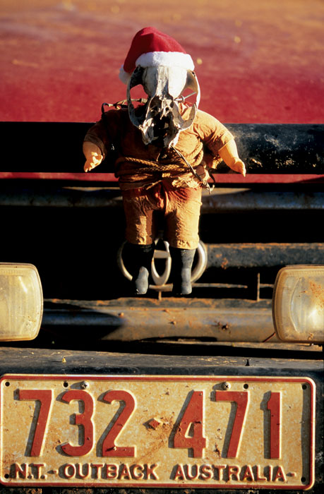
Hardcore Santana the travelling mascot, constructed of parts collected along the way. Image by Robyn Rosenfeldt

Driving into the Gammon Ranges National Park, the mountains rise up around us, erasing the monotony of the vast open plains. Despite our desire to camp rough we head into the Arkaroola Wilderness Sanctuary and Arkaroola itself. After camping wherever we want most nights, we’re a bit perturbed to have to set up in a designated site in Arkaroola, but the pull of their swimming pool and air-conditioned bar wins out.
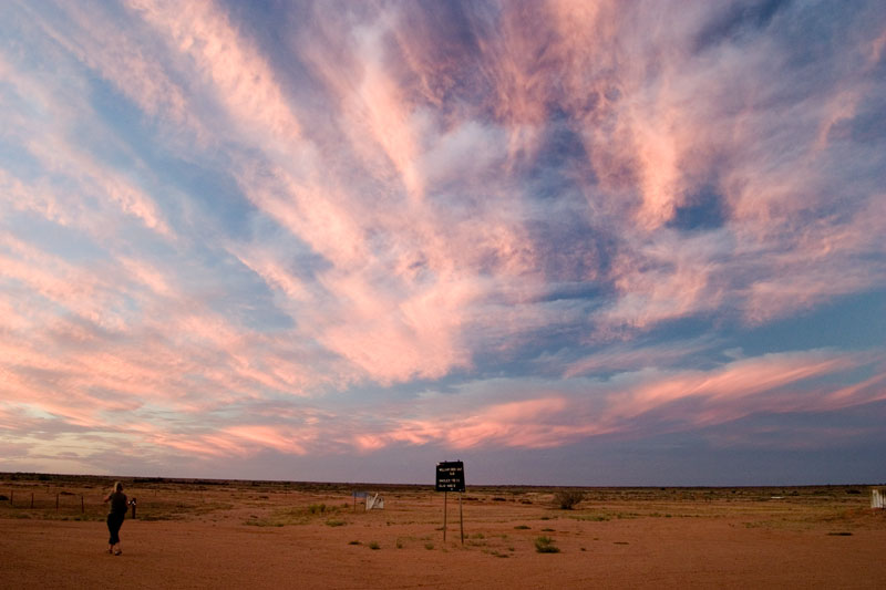
Sunset over the desert from outside the William Creek Hotel. Image by Robn Rosenfeldt

Our night in semi-civilisation is really just preparing us for our gradual immersion back into the populated world. The next morning we leave the ranges behind and head south, our tyres taking their first spin on bitumen as we hit the Barrier Highway on our way to Broken Hill.

Weekly travel news, experiences
insider tips, offers, and more.

Mungo Dreaming

After crossing the border into NSW at Cockburn, we ponder the origins of such a name, hoping it didn’t involve a nasty incident between a hot billy and an early explorer. We pass through Broken Hill for lunch and take the road southeast to Menindee and the surrounding lakes to a spot called Copi Hollow, where we camp by the shores of the Menindee Lakes. It’s here that Burke and Wills spent their final months before heading off on their ill-fated trip across unknown terrain to the north. From Menindee, we take the road to Pooncarie and turn off to Lake Mungo National Park, home to some of the oldest remnants of human existence. The following morning, after climbing the impressive sand dunes and exploring the old woolshed, we decide we’ve had enough. It’s time to make our way south, into Victoria.

Across Victoria to journey’s end

Pulling into civilisation – and yes, you can call Mildura that – our rugged attire makes us look like country hillbillies in contrast to the slick, made-up townsfolk. After sipping a very disappointing latte (which I’ve been looking forward to for days) we buy more supplies and find a spot to camp, just east of town on the banks of the mighty Murray.


As the golden afternoon sun lights up the huge river red gums lining the bank, we dive deep into the cool, refreshing water. The lush vegetation seems like a green paradise in comparison to where we’ve been. We have a beautiful night feasting on snags and steaks and watching shooting stars pass above the spreading limbs of the red gums overhead.
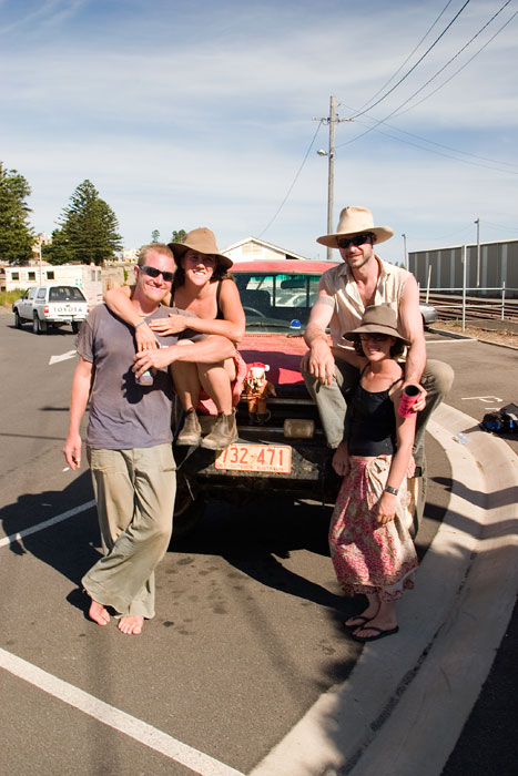
The travelling team at journey’s end. Image by Robyn Rosenfeldt

Our final day on the road starts early. Driving south, we skirt the western edge of the Grampians and drive through the reassuring yellow of the Victorian wheat fields, hitting the coast at Port Fairy. As we pull up to the water’s edge, the endless expanse of blue stretches before us, as vast and flat as the deserts we’ve driven through.


It’s been an amazing journey. In ten days we’ve crossed our gigantic continent from the red centre to the distant coast – a lot of the time on back roads seemingly to nowhere. But that almost seems the best approach; you experience so much more and the journey is that much more satisfying. We’ve seen the landscape, the colours and the weather change dramatically. And I think a little bit of each of us has changed too.

Want to see more stories from Australian Traveller in your Google search results?

  1. Click here to set Australian Traveller as a preferred source.
  2. Tick the box next to "Australian Traveller". That's it.
Australian Traveller

Australian Traveller

View profile and articles
hero media

7 Kimberley experiences that need to be on your bucket list

From thundering waterfalls to ancient Indigenous art, Kimberley’s raw beauty will take your breath away.

Wild, pristine, and shaped by nature, the Kimberley Coast is one of Australia’s most spectacular landscapes. A remote and rugged frontier that remains a bucket list destination for many travellers. Its most breathtaking attractions – including Montgomery Reef, King George Falls and Horizontal Falls – are accessible only by sea or air, making a guided expedition cruise aboard Silversea’s luxury expedition ship, Silver Cloud, the ideal way to explore it.

From its intricate intertidal zones to ancient rock art, extreme tides and rare wildlife found nowhere else in Australia – or the world – this journey offers an unparalleled exploration of one of Earth’s last true wildernesses.

Why Silversea?

Silversea offers a 10-day expedition departing Broome, or an extended 16-day expedition voyage from Indonesia, including landings on the hidden gems of Palopo Sulawesi and Komodo. Accompanied by expert guides and specialists in marine biology, history and geology, guests gain a deeper understanding of the Kimberley’s dramatic landscapes, rich cultural heritage and extraordinary biodiversity.

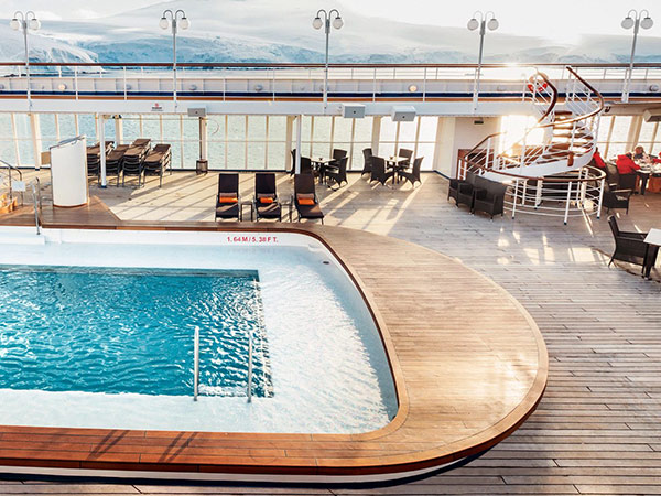
Silversea offers one of the experiential travel industry’s leading crew-to-guest ratios. Along with all-suite accommodation (80 per cent with private verandah), 24-hour butler service, a swimming pool and four dining options. Silver Cloud also has an experienced crew of multilingual expedition guides and specialists in marine biology, history and geology to enhance your Kimberley Experience.

silversea cruise ship pool deck
Take a dip in the pool deck.

1. Koolama Bay

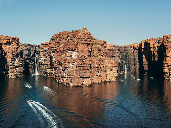
​​Before visitors see King George Falls, they hear them – a growing rumble in the distance, steady and foreboding as the Zodiac glides through the gorge, the sound echoing off sheer rock formations. At 80 meters tall, the twin cascades carve through the red cliffs, churning the waters below in a spectacular finale – but Koolama Bay holds secrets beyond its striking scenery.

Named after a ship that beached here following an aerial attack by Japanese bombers in World War II, the bay may seem desolate, yet it teems with life. With Silversea’s expert guides on their 10-day Kimberley itinerary, guests gain a sharper eye for its hidden wonders – rock wallabies darting across the cliffs, crocodiles lurking among dense green mangroves, and high above, the silhouette of a bird of prey circling the sky.

King George Falls at koolama bay excursion on Silversea Kimberley Cruise
Take a shore excursion to see King George Falls.

2. Freshwater Cove / Wijingarra Butt Butt

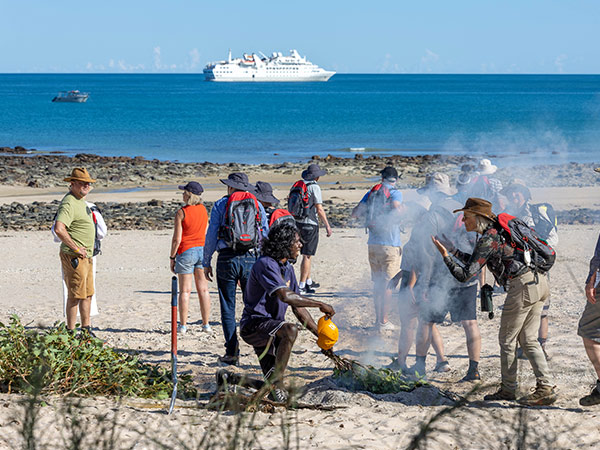
Connect with Country on a wet landing at Freshwater Cove, also known as Wijingarra Butt Butt. Considered one of the most special experiences on both the 16-day and 10-day Kimberley cruises, Silversea guests are welcomed by the traditional Indigenous custodians of the land, painted with traditional ochre, and invited to take part in a smoking ceremony.

Located on the mainland near Montgomery Reef, Wijingarra Butt Butt holds deep cultural significance to the local Indigenous community. Here, rock formations along the shore represent spiritual ancestors, and guests are guided to a nearby rock overhang filled with ancient art, where traditional owners share the stories and meaning behind these sacred paintings.

welcome to country on freshwater cove during silversea kimberley cruise
Take part in a smoking ceremony. (Image: Tim Faircloth)

3. Vansittart Bay (Jar Island)

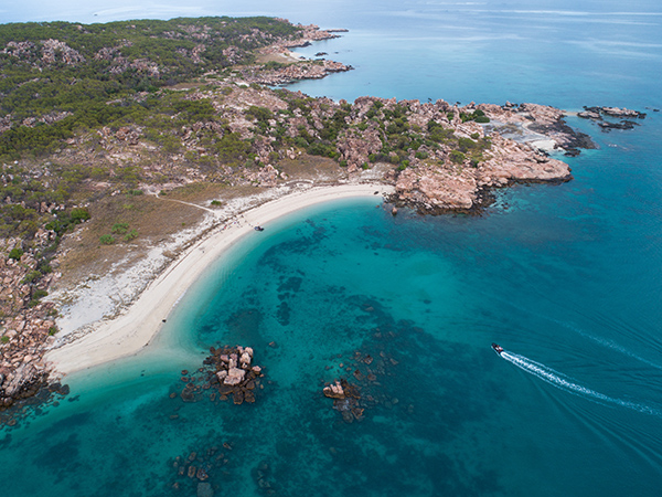
Modern history, ancient culture and mystery converge in Vansittart Bay, which is also known as Jar Island. Here, the first thing to catch the eye is the dented, silver fuselage of a World War II-era C-53 plane – a striking relic of the past. Yet, the true cultural treasures lie just a short hike away where two distinct styles of Indigenous rock art – Gwion Gwion and Wandjina – can be found.

The Wandjina figures, deeply connected to Indigenous traditions, stand in stark contrast to the enigmatic Gwion Gwion (Bradshaw) paintings, which date back more than 12,000 years. Significantly different in form and style, the two different styles create a striking juxtaposition, offering a rare glimpse into the region’s rich and complex past.

aerial view of Vansittart Bay, See it in you Silversea Kimberley Cruise.
Explore ancient Gwion Gwion rock art at Vansittart Bay. (Image: Janelle Lugge)

4. Horizontal Falls

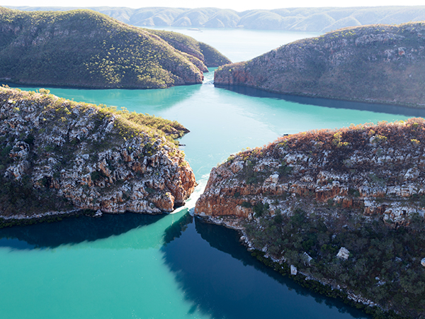
Part illusion, part natural phenomenon, the Kimberley’s much-lauded Horizontal Falls aren’t a waterfall, but a tidal and geographic spectacle that visitors have to see to comprehend. Known as Garaanngaddim, the phenomenon occurs when seawater rushes through two narrow gaps- one just twenty metres wide, and the other seven metres in width, between the escarpments of Talbot Bay.

With each tidal shift,  the force of the water creates whirlpools, furious currents and the illusion of a horizontal cascade as thousands of gallons of water are pushed and pulled in through the gap every six hours with relentless movement, making this one of the Kimberley’s most mesmerising natural wonders.

Horizontal Falls are described as "One of the greatest wonders of the natural world". They are formed from a break in-between the McLarty Ranges reaching up to 25m in width. The natural phenomenon is created as seawater builds up faster on one side of the gaps than the other, creating a waterfall up to 5m high on a King tide.
Watch whirlpools and furious currents collide. (Image: Janelle Lugge)

5. Montgomery Reef

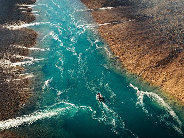
As the tide turns in Montgomery Reef, magic happens. With the Kimberley’s legendary tides varying up to ten metres, at low tide the submerged reef almost appears to rise from the depths: exposing up to four metres of the sandstone reef.

The impact is otherworldly: as the water drains, waterfalls cascade on either side of the channel,  turtles left exposed scramble and dive, and fish leap in search of sanctuary in shallow pools. Meanwhile, the dinner bell rings for the migratory seabirds dugongs, reef sharks and dolphins that scavenge and feast in the area.

Using zodiacs, guests cruise through one of the world’s most significant inshore reef systems navigated by experienced guides, exploring the most intricate and fascinating parts of a 300-square-kilometre-wide biodiversity hotspot.

aerial view of boat going along Montgomery Reef
Witness seabirds, dolphins and reef sharks on the hunt.

6. Mitchell Falls by Helicopter

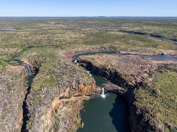
Experiencing the Kimberley by sea allows you to feel the power of the tides, but travelling by helicopter reveals the sandstone tapestry of the Kimberley, a landscape geologists believe is over 1.8 billion years old.

One of Silversea’s most popular optional excursions, guests who opt to fly into the interior from the onboard helipad soar up above the rust-coloured landscape of the Mitchell plateau, taking in one of Australia’s most scenic waterfalls: Mitchell Falls, a series of four emerald-coloured pools gently cascades into each other, before plunging down to the river below.

Seeing the landscape from above reveals a landscape weaved and shaped by the power of the freshwater wet season, juxtaposed to the constant lapping of the relentless and powerful tide on the coast.

aerial view of mitchell falls on silversea helicopter excursion
See emerald pools cascade into the river below. (Image: Tim Faircloth)

7. Indigenous Art Caves, Wandjina Art

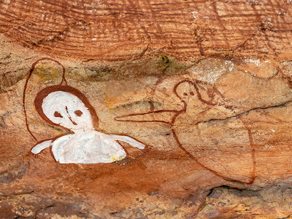
The Kimberley Region of Western Australia is home to some of the most striking and significant

Indigenous rock art in Australia. Dotted throughout the landscape are caves, cliffs and rock overhangs depicting the striking, ethereal image of Wandjina, the rainmaker spirit and creation being central to many of the Dreamtime stories in this region.

Some of the paintings are regularly repainted by traditional custodians, while others are believed to be over 4,000 years old. Each artwork serves as both a cultural record and a living connection to the past, offering a rare opportunity to engage with the enduring traditions of the Kimberley’s Indigenous communities.

Freshwater Cover Rock Art the kimberleys
Walk among cultural records preserved in stone. (Image: Tim Faircloth)

See the best of this incredible part of the world on a Silversea Kimberley cruise. Book your 10- or extended 16-day expedition voyage at silversea.com